SAINT-RÉMY-DE-PROVENCE – La crête des Alpilles – Saint-Rémy-de-Provence
Description
English
Deutsch
Dutch
Español
Italiano
Description
Depuis le parking des Antiques, longer la D5 en direction de Saint-Rémy-de-Provence, et tourner à droite pour rejoindre le Cloître Saint-Paul de Mausole, au bout de l’allée bordée de platanes.
1- Face au Cloître, suivre la route sur la droite afin de le contourner. Au niveau du panneau Relais Information Service du Parc naturel régional des Alpilles, emprunter le chemin des Carrières sur la droite. Suivre le sentier balisé PR (en jaune) qui traverse vallon et forêt.
2- Au carrefour avec la petite route goudronnée, suivre celle-ci à gauche. Continuer sur la route jusqu'à la tour de télécommunication du plateau de la Caume. Au niveau de la tour, partir à gauche en direction du GR®6. Après le panneau du "Biotope", suivre à droite la ligne de crête par une série de pas rocheux.
3- Après 2 km, basculer sur la droite en suivant le GR®6 et rejoindre le pied des crêtes. Continuer entre passages rocheux et sous-bois jusqu'au col de la Vallongue et son défilé rocheux. Le descendre à gauche jusqu'à un chemin roulant proche de l'aérodrome (certains passages nécessitent les mains).
4- Emprunter le chemin à gauche. À partir de ce point, le circuit sera doublement balisé PR (jaune) et GR® (rouge/blanc) jusqu'à l'arrivée. Continuer sur 3 km, en restant attentif au marquage, jusqu'à une jonction de chemins balisés et une propriété bordée de murs.
5- Tourner à gauche et parcourir 500 m. Emprunter à droite une piste, puis une petite route goudronnée. Au virage en épingle, bifurquer sur le chemin à gauche bordé de propriétés.
6- À la fourche, rester sur la droite, plus loin passer une barrière, puis continuer jusqu'à un cabanon en pierre. Après le cabanon, virer à gauche. Couper le chemin où passe le GR®6, remonter entre deux barrières en bois et continuer à droite sur le chemin qui rejoint le point de départ.
English
The burial works of the High Voltage line of the Caume, Saint-Rémy-de-Provence will take place between 18/09/2017 and 22/12/2017, down from the telecommunication relay to the Plaines car park. Diversion routes will be set up except for the portion between Vallon de Valrugues and the plateau, on the route of Gr6, which will be completely closed for a few weeks. Consult the map of the works on the Park's website for more details. From the Antiques car park, along the D5 towards Saint-Rémy-de-Provence, and turn right to join the Cloister of Saint Paul Mausole, at the end of the path lined with plane trees.
1- Facing the Cloister, follow the road on the right to bypass it. At the Relais Information Service panel of the Alpilles Regional Nature Park, take Chemin des Carrières on the right. Follow the marked path PR (in yellow), which crosses valley and forest.
2- At the crossroads with the small paved road, follow it to the left. Continue on the road to the telecommunication tower of the Caume plateau. At the tower, turn left towards GR®6. After the sign of "Biotope", follow the ridge line to the right by a series of rocky steps.
3- After 2 km, turn to the right following the GR®6 and join the foot of the peaks. Continue between rocky passages and undergrowth to the Vallongue pass and its rocky gorge. Go down to the left to a road near the airfield (some passages require the hands).
4- Take the path on the left. From this point the circuit will be double marked PR (yellow) and GR® (red / white) until arrival. Continue for 3 km, remaining attentive to the marking, until a junction of marked paths and a property lined with walls.
5- Turn left and walk 500 m. Take a track on the right and then a small asphalt road. At the hairpin bend, turn left onto the path lined with properties.
6- At the fork stay on the right, further pass a barrier then continue to a stone cottage. After the shed, turn left. Cut the path where the GR®6 passes, go up between two wooden barriers and continue to the right on the path that joins the starting point.
Deutsch
Vom Parkplatz Les Antiques aus folgen Sie der D5 in Richtung Saint-Rémy-de-Provence und biegen rechts ab, um das Kloster Saint-Paul de Mausole zu erreichen, das sich am Ende der von Platanen gesäumten Allee befindet.
1- Gegenüber dem Kloster folgen Sie der Straße auf der rechten Seite, um es zu umgehen. Am Schild Relais Information Service du Parc naturel régional des Alpilles nehmen Sie den Chemin des Carrières auf der rechten Seite. Folgen Sie dem mit PR (gelb) markierten Weg, der durch ein Tal und einen Wald führt.
2- An der Kreuzung mit der kleinen asphaltierten Straße folgen Sie dieser nach links. Gehen Sie auf der Straße weiter bis zum Fernmeldeturm des Plateau de la Caume. Am Turm gehen Sie nach links in Richtung GR®6. Nach dem Schild "Biotope" folgen Sie rechts der Kammlinie über eine Reihe von felsigen Schritten.
3- Nach 2 km rechts abbiegen und dem GR®6 folgen, bis Sie den Fuß des Kamms erreichen. Gehen Sie zwischen felsigen Passagen und Unterholz weiter, bis Sie den Col de la Vallongue mit seiner felsigen Schlucht erreichen. Gehen Sie links hinunter bis zu einem Rollweg in der Nähe des Flugplatzes (einige Passagen erfordern die Hände).
4- Nehmen Sie den Weg nach links. Ab hier ist der Rundweg bis zum Ziel doppelt markiert: PR (gelb) und GR® (rot/weiß). Gehen Sie 3 km weiter und achten Sie auf die Markierungen, bis Sie zu einer Kreuzung markierter Wege und einem von Mauern gesäumten Grundstück kommen.
5- Biegen Sie links ab und gehen Sie 500 m weiter. Gehen Sie rechts auf einen Weg und dann auf eine kleine asphaltierte Straße. In der Haarnadelkurve zweigen Sie auf den linken Weg ab, der von Grundstücken gesäumt ist.
6- Halten Sie sich an der Gabelung rechts, gehen Sie weiter über einen Zaun und dann weiter bis zu einem Steinhäuschen. Nach der Hütte biegen Sie links ab. Kreuzen Sie den Weg, auf dem der GR®6 verläuft, steigen Sie zwischen zwei Holzbarrieren auf und gehen Sie rechts auf dem Weg weiter, der zum Ausgangspunkt zurückführt.
Dutch
Volg vanaf de parkeerplaats Antiques de D5 richting Saint-Rémy-de-Provence en sla rechtsaf om bij het Cloître Saint-Paul de Mausole te komen, aan het einde van de laan met platanen.
1- Sla voor het klooster rechtsaf om er omheen te gaan. Ga bij het bord Relais Information Service du Parc naturel régional des Alpilles naar rechts over het pad Chemin des Carrières. Volg het gele PR-pad door de vallei en het bos.
2- Ga bij de kruising met de kleine asfaltweg naar links. Blijf de weg volgen tot aan de telecommunicatietoren op het Plateau de la Caume. Sla bij de toren linksaf richting de GR®6. Na het bord "Biotope" volgt u de bergkam naar rechts over een reeks rotsachtige trappen.
3- Sla na 2 km rechtsaf langs de GR®6 en bereik de voet van de bergkam. Ga verder door rotsachtige passages en kreupelhout naar de Col de la Vallongue en zijn rotsachtige kloof. Sla linksaf naar beneden naar een glooiend pad in de buurt van het vliegveld (sommige stukken vereisen handen).
4- Neem het pad aan de linkerkant. Vanaf dit punt is het circuit dubbel gemarkeerd PR (geel) en GR® (rood/wit) tot aan de finish. Ga 3 km door, let goed op de markeringen, tot je bij een kruising komt van gemarkeerde paden en een terrein omzoomd door muren.
5- Ga naar links en vervolg de route voor 500 m. Neem een pad aan de rechterkant, daarna een kleine asfaltweg. Ga bij de haarspeldbocht naar links een pad op dat wordt begrensd door eigendommen.
6- Bij de splitsing rechts aanhouden, een hek door en doorlopen tot aan een stenen huisje. Ga na het schuurtje naar links. Steek het pad over waar de GR®6 passeert, ga omhoog tussen twee houten hekken door en ga verder naar rechts over het pad terug naar het beginpunt.
Español
Desde el aparcamiento de Antigüedades, siga la D5 en dirección a Saint-Rémy-de-Provence y gire a la derecha para llegar al Claustro Saint-Paul de Mausole, al final de la avenida bordeada de plátanos.
1- Delante del Claustro, gire a la derecha para rodearlo. En el cartel Relais Information Service du Parc naturel régional des Alpilles, gire a la derecha por el camino Chemin des Carrières. Siga el sendero PR amarillo a través del valle y del bosque.
2- En el cruce con la pequeña carretera asfaltada, gire a la izquierda. Continúe por la carretera hasta la torre de telecomunicaciones del Plateau de la Caume. En la torre, gire a la izquierda hacia el GR®6. Después de la señal "Biotope", siga la línea de cresta a la derecha por una serie de escalones rocosos.
3- Después de 2 km, girar a la derecha por el GR®6 y llegar al pie de la cresta. Continuar por pasos rocosos y maleza hasta el Col de la Vallongue y su desfiladero rocoso. Bajar a la izquierda por una pista ondulada cerca del aeródromo (algunos tramos requieren manos).
4- Tomar la pista de la izquierda. A partir de este punto, el circuito está doblemente marcado PR (amarillo) y GR® (rojo/blanco) hasta la meta. Continúe durante 3 km, prestando mucha atención a las marcas, hasta llegar a un cruce de caminos señalizados y a una propiedad delimitada por muros.
5- Gire a la izquierda y continúe 500 m. Tomar una pista a la derecha, luego una pequeña carretera asfaltada. En la curva cerrada, girar a la izquierda por una pista bordeada de propiedades.
6- En la bifurcación, manténgase a la derecha, atraviese una verja y continúe hasta una cabaña de piedra. Después del cobertizo, girar a la izquierda. Cruzar el camino por donde pasa el GR®6, subir entre dos vallas de madera y continuar a la derecha por la pista de vuelta al punto de partida.
Italiano
Dal parcheggio dell'Antiquariato, seguire la D5 in direzione di Saint-Rémy-de-Provence e svoltare a destra per raggiungere il Cloître Saint-Paul de Mausole, alla fine del viale fiancheggiato da platani.
1- Davanti al Chiostro, girare a destra per aggirarlo. Al cartello Relais Information Service du Parc naturel régional des Alpilles, girare a destra sul sentiero Chemin des Carrières. Seguire il sentiero giallo PR attraverso la valle e la foresta.
2- All'incrocio con la piccola strada asfaltata, girare a sinistra. Proseguire sulla strada fino alla torre di telecomunicazione sul Plateau de la Caume. Alla torre, svoltare a sinistra verso il GR®6. Dopo il cartello "Biotope", seguire la linea di cresta a destra attraverso una serie di gradini rocciosi.
3- Dopo 2 km, svoltare a destra lungo il GR®6 e raggiungere i piedi della cresta. Proseguire attraverso passaggi rocciosi e sottobosco fino al Col de la Vallongue e alla sua gola rocciosa. Girare a sinistra e scendere su un sentiero ondulato vicino al campo d'aviazione (alcuni tratti richiedono l'uso delle mani).
4- Prendere la pista a sinistra. Da questo punto in poi, il circuito è doppiamente segnato PR (giallo) e GR® (rosso/bianco) fino all'arrivo. Si prosegue per 3 km, facendo molta attenzione alle indicazioni, fino a un incrocio di sentieri segnalati e a una proprietà delimitata da muri.
5- Girare a sinistra e proseguire per 500 m. Imboccare un sentiero sulla destra, poi una piccola strada asfaltata. Al tornante, svoltare a sinistra su un sentiero delimitato da proprietà.
6- Al bivio, tenere la destra, oltrepassare un cancello e proseguire fino a una casetta in pietra. Dopo il capannone, svoltare a sinistra. Attraversare il sentiero dove passa il GR®6, salire tra due staccionate di legno e tenere la destra sul sentiero per tornare al punto di partenza.
Type:
Distance: 16490.0
Durée: 360mn
, 13210 Saint-Rémy-de-Provence
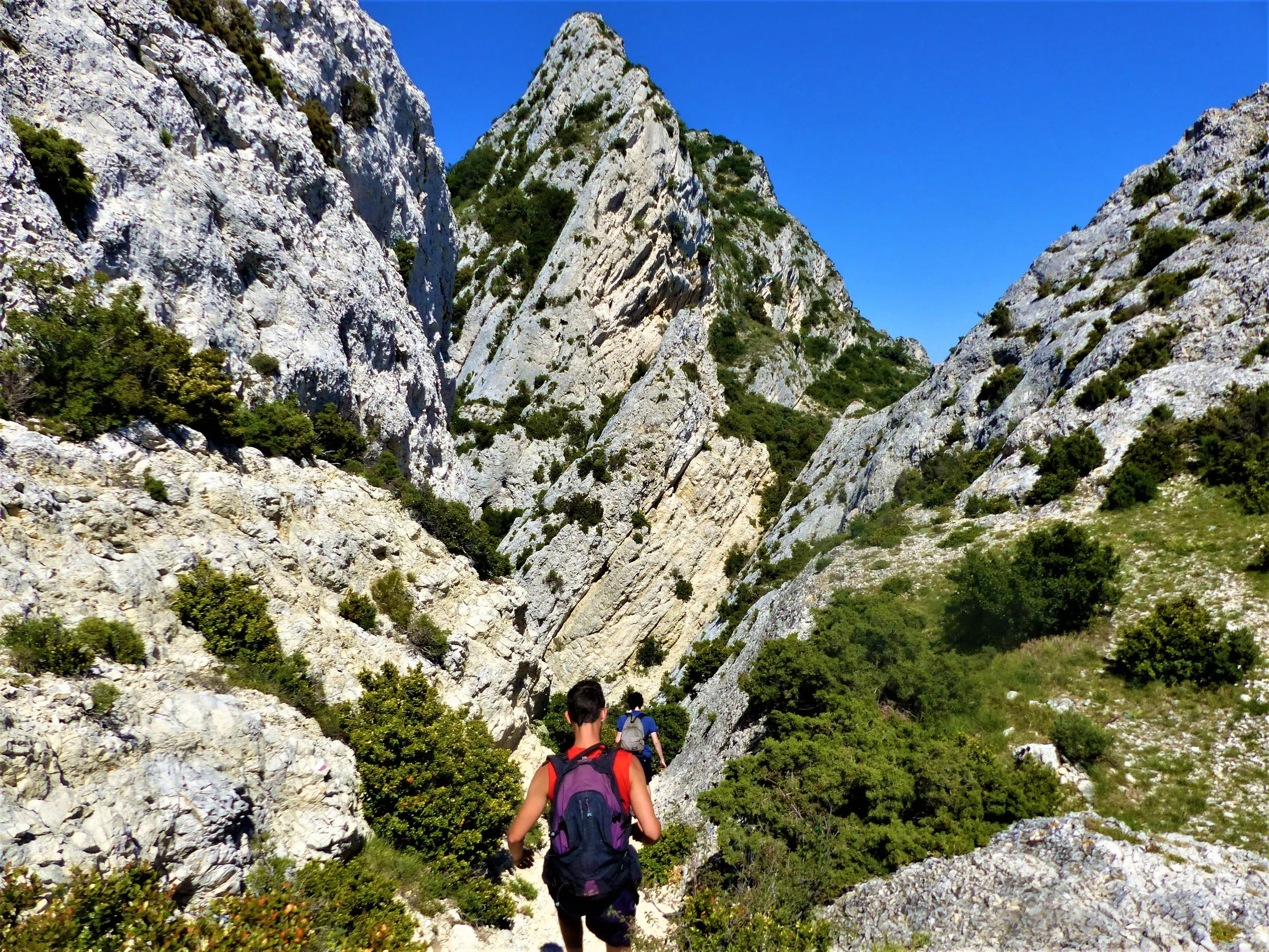
Crédits: ©Rémi Sérange - PNR Alpilles
Publications similaires :
 SAINT-RÉMY-DE-PROVENCE – La crête des Alpilles – Saint-Rémy-de-Provence
  SAINT-RÉMY-DE-PROVENCE – À vélo, les Alpilles par le Val d'Enfer – Saint-Rémy-de-Provence
  SAINT-RÉMY-DE-PROVENCE – De Saint-Rémy aux Baux – Saint-Rémy-de-Provence SAINT-RÉMY-DE-PROVENCE – De Saint-Rémy aux Baux – Saint-Rémy-de-Provence