CIRCUIT – LE TOUR DE BRAMONT – Plainfaing
Description
English
Deutsch
Dutch
Español
Italiano
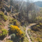
Description
Balisage : disque bleu / durée 2h30 / distance 11km / dénivelé : 370m en montée
D415 direction col du Bonhomme. Un chemin part sur la droite puis monte vers la Ferme – auberge « Les Grands Prés » Départ du parking de la ferme – auberge (y laisser votre véhicule)
Le circuit démarre à gauche de la ferme, vous continuez par La Hardalle, Varcivaux et Le Faing du Souche qui vous offrira une vue magnifique sur la vallée de la Haute-Meurthe, Xéfosse et le Rudlin, puis au loin sur le Hohneck. Au retour, profiter de la vue sur le col du Bonhomme et le vallon de Barançon. Votre randonnée se termine à votre point de départ, parking de la ferme-auberge.
English
Beaconing: blue disc / duration 2h30 / distance 11km / altitude difference: 370m uphill
D415 direction Col du Bonhomme. A path goes on the right then goes up towards the Farm – inn " Les Grands Prés " Departure from the car park of the farm – inn (leave your car there)
The circuit starts on the left side of the farm, you continue through La Hardalle, Varcivaux and Le Faing du Souche which will offer you a magnificent view over the Haute-Meurthe valley, Xéfosse and the Rudlin, then in the distance over the Hohneck. On the way back, enjoy the view over the Col du Bonhomme and the Barançon valley. Your hike ends at your starting point, the parking lot of the farmhouse inn.
Deutsch
Markierung: blaue Scheibe / Dauer 2,5 Stunden / Entfernung 11km / Höhenunterschied: 370m im Aufstieg
D415 Richtung Col du Bonhomme. Ein Weg zweigt rechts ab und führt dann hinauf zur Ferme – Auberge " Les Grands Prés ". Sie starten auf dem Parkplatz der Ferme – Auberge (lassen Sie dort Ihr Fahrzeug stehen)
Der Rundweg beginnt links vom Bauernhof und führt Sie weiter über La Hardalle, Varcivaux und Le Faing du Souche, von wo aus Sie einen herrlichen Blick auf das Tal der Haute-Meurthe, Xéfosse und den Rudlin und in der Ferne auf den Hohneck haben. Genießen Sie auf dem Rückweg die Aussicht auf den Col du Bonhomme und das Barançon-Tal. Ihre Wanderung endet an Ihrem Ausgangspunkt, dem Parkplatz der Ferme-Auberge.
Dutch
Markering: blauwe schijf / duur 2u30 / afstand 11km / hoogteverschil: 370m bergopwaarts
D415 richting Col du Bonhomme. Een pad leidt naar rechts en klimt vervolgens naar de boerderijherberg "Les Grands Prés". Vertrek vanaf de parkeerplaats van de boerderijherberg (laat uw voertuig daar achter)
Het circuit begint links van de boerderij, u rijdt door La Hardalle, Varcivaux en Le Faing du Souche die u een prachtig uitzicht biedt op de vallei van de Haute-Meurthe, Xéfosse en de Rudlin, en vervolgens in de verte op de Hohneck. Geniet op de terugweg van het uitzicht op de Col du Bonhomme en de vallei van Barançon. Uw wandeling eindigt bij uw vertrekpunt, de parkeerplaats van de boerderij.
Español
Marcaje: disco azul / duración 2h30 / distancia 11km / desnivel: 370m de subida
D415 hacia Col du Bonhomme. Un camino sale a la derecha y luego sube hacia la granja y la posada "Les Grands Prés". Salida desde el aparcamiento de la granja y la posada (dejar el vehículo allí)
El circuito comienza a la izquierda de la granja, se continúa por La Hardalle, Varcivaux y Le Faing du Souche que le ofrecerá una magnífica vista del valle de Haute-Meurthe, Xéfosse y el Rudlin, luego en la distancia en el Hohneck. A la vuelta, disfrute de la vista del puerto de Bonhomme y del valle de Barançon. La caminata termina en el punto de partida, el aparcamiento de la granja.
Italiano
Marcatura: disco blu / durata 2h30 / distanza 11km / dislivello: 370m in salita
D415 verso il Col du Bonhomme. Un sentiero si stacca sulla destra e poi sale verso l'agriturismo "Les Grands Prés". Partenza dal parcheggio dell'agriturismo (lasciare il veicolo)
Il circuito inizia a sinistra della fattoria, si prosegue attraverso La Hardalle, Varcivaux e Le Faing du Souche che vi offrirà una magnifica vista sulla valle dell'Alta Murthe, Xéfosse e il Rudlin, poi in lontananza sull'Hohneck. Al ritorno, godetevi la vista sul colle Bonhomme e sulla valle del Barançon. L'escursione termina al punto di partenza, il parcheggio dell'agriturismo.
Pédestre
Clientèle: Groupes
Type:
Distance: 11000.0
Durée: 150mn
42 Ter Habeaurupt, 88230 Plainfaing
Crédits: OT SAINT DIE DES VOSGES