Circuit de la Chapelle de Dun – Saint-Racho
Description
English
Deutsch
Dutch
Español
Italiano
Description
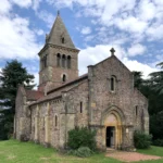
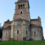
Départ du bourg, vers la croix de la Chaux, prenez à gauche, puis ensuite à droite au cimetière, entre pâturages et forêts, il faut grimper la côte de Collonges. Beau point de vue tout en haut. Continuez dans les bois. Tournez à droit, puis à la sortie du bois, vous découvrez le côté Rhône avec vue sur le Mont St Rigaud (1012m). Passant par la Croix du Plâtre, vous longerez Anglure-sous-Dun, puis Mussy-sous-Dun avec vue sur son viaduc (61 m au plus haut). Ce circuit vous mènera à 708 m d'altitude, jusqu'à la Chapelle de Dun, (jadis "Dun le Roy"), vestige d'un passé glorieux. Le circuit chemine ensuite dans les bois jusqu'aux Corneloups, puis après un beau panorama à gauche sur La Clayette et ses environs, rejoignez Les Gauthiers. La fin du circuit passe par Le Cornet et retour au point de départ au Bourg.
English
Departure from the village, towards the cross of La Chaux, turn left, then right at the cemetery, between pastures and forests, you have to climb the hill of Collonges. Beautiful viewpoint at the top. Continue in the woods. Turn right, then at the end of the wood, you discover the Rhône side with a view on the Mont St Rigaud (1012m). Passing by the Croix du Plâtre, you will go along Anglure-sous-Dun, then Mussy-sous-Dun with a view on its viaduct (61 m at the highest). This circuit will lead you at 708 m of altitude, to the Chapel of Dun, (formerly "Dun le Roy"), vestige of a glorious past. The circuit then goes through the woods to Les Corneloups, then after a beautiful panorama on the left on La Clayette and its surroundings, reach Les Gauthiers. The end of the circuit passes by Le Cornet and returns to the starting point in Le Bourg.
Deutsch
Starten Sie im Dorf, beim Kreuz von La Chaux, biegen Sie links ab, dann rechts beim Friedhof. Zwischen Weiden und Wäldern müssen Sie die Côte de Collonges erklimmen. Schöner Aussichtspunkt ganz oben. Gehen Sie weiter durch den Wald. Biegen Sie rechts ab und am Ende des Waldes entdecken Sie die Rhône-Seite mit Blick auf den Mont St Rigaud (1012 m). Über das Croix du Plâtre fahren Sie an Anglure-sous-Dun vorbei, dann an Mussy-sous-Dun mit Blick auf sein Viadukt (61 m an der höchsten Stelle). Dieser Rundweg führt Sie auf 708 m Höhe zur Kapelle von Dun (früher "Dun le Roy"), einem Überbleibsel aus einer glorreichen Vergangenheit. Der Rundweg führt dann durch die Wälder bis nach Les Corneloups. Nach einem schönen Panoramablick nach links auf La Clayette und seine Umgebung erreichen Sie Les Gauthiers. Das Ende des Rundwegs führt durch Le Cornet und zurück zum Ausgangspunkt in Le Bourg.
Dutch
Vanuit het dorp, richting het kruis van La Chaux, linksaf, dan rechtsaf bij het kerkhof, tussen weilanden en bossen door, moet u de Collonges heuvel beklimmen. Prachtig uitzichtpunt op de top. Verder door het bos. Rechtsaf, aan het eind van het bos ontdekt u de Rhône-kant met uitzicht op de Mont St Rigaud (1012m). Langs het Croix du Plâtre, komt u langs Anglure-sous-Dun en vervolgens Mussy-sous-Dun met uitzicht op het viaduct (61 m op het hoogste punt). Dit circuit brengt u naar een hoogte van 708 m, tot aan de Chapelle de Dun, (vroeger "Dun le Roy"), een overblijfsel van een roemrijk verleden. De route gaat vervolgens door de bossen naar Les Corneloups, om vervolgens na een prachtig panorama links over La Clayette en omgeving, Les Gauthiers te bereiken. Het einde van het circuit loopt langs Le Cornet en keert terug naar het beginpunt in Le Bourg.
Español
Desde el pueblo, hacia la cruz de La Chaux, girar a la izquierda, luego a la derecha en el cementerio, entre pastos y bosques, hay que subir la colina de Collonges. Hermoso mirador en la cima. Continuar por el bosque. Gire a la derecha y, al final del bosque, descubrirá la vertiente del Ródano con vistas al Mont St Rigaud (1012 m). Pasando por la Croix du Plâtre, recorrerá Anglure-sous-Dun, luego Mussy-sous-Dun con una vista de su viaducto (61 m en su punto más alto). Este circuito le llevará a una altitud de 708 m, hasta la Chapelle de Dun, (antiguamente "Dun le Roy"), vestigio de un pasado glorioso. A continuación, el itinerario atraviesa el bosque hasta Les Corneloups y, tras un hermoso panorama a la izquierda sobre La Clayette y sus alrededores, llega a Les Gauthiers. El final del circuito pasa por Le Cornet y regresa al punto de partida en Le Bourg.
Italiano
Dal villaggio, verso la croce di La Chaux, si gira a sinistra, poi a destra al cimitero, tra pascoli e boschi, si deve salire sulla collina di Collonges. Bellissimo punto panoramico in cima. Proseguire attraverso il bosco. Si gira a destra, poi alla fine del bosco si scopre il versante del Rodano con vista sul Mont St Rigaud (1012 m). Passando per la Croix du Plâtre, si costeggia Anglure-sous-Dun, poi Mussy-sous-Dun con vista sul suo viadotto (61 m nel punto più alto). Questo circuito vi porterà a 708 m di altitudine, fino alla Chapelle de Dun (ex "Dun le Roy"), vestigia di un passato glorioso. Il percorso si snoda poi nel bosco fino a Les Corneloups, quindi, dopo un bel panorama a sinistra su La Clayette e i suoi dintorni, raggiunge Les Gauthiers. La fine del circuito passa per Le Cornet e ritorna al punto di partenza a Le Bourg.
Pédestre
Type:
Distance: 9900.0
Le Bourg, 71800 Saint-Racho

Crédits: Communauté de Communes BSB