Autour du Puits Hottinguer – Épinac
Description
English
Deutsch
Dutch
Español
Italiano
Description
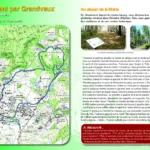
– Traverser le parking derrière la mairie en oblique vers la droite pour prendre un chemin de terre qui rejoint le tracé de l'ancienne voie de chemin de fer. La prendre à droite. – Traverser le pont du chemin de fer et prendre immédiatement sur la droite le sentier qui redescend sur la rue Roger Salengro. Continuer tout droit sur la D43 direction « La Drée », et prendre la première à droite vers le camping.
– Passer devant l’Office de Tourisme, continuer tout droit le long de la rivière, passer le pont à droite juste avant le camping et continuer sur la gauche. Longer la rivière, jusqu’à la prochaine passerelle à gauche. (Attention passerelle très glissante). Suivre le chemin jusqu’à la route goudronnée, prendre à gauche.
– Au stop, traverser la départementale, continuer sur la gauche et prendre la première rue à droite « Rue Jean Diot », et la première à gauche « Rue Barlibeau ». Tout droit sur environ 1 km (vue sur la tour Malakoff), prendre un petit chemin à gauche qui descend entre deux prés (attention ne pas aller jusqu’au carrefour de la nationale). Tout droit, passer un petit pont en fer gris, continuer jusqu’à la route.
– Prendre tout de suite à gauche, le petit chemin « Promenade de Monestoy », tout droit pendant 800 m, passer devant l’ancienne gare, tout droit sur un petit chemin, puis une route (repère tour sur la gauche).
– Au stop, traverser et prendre en face l’Allée François Mitterand, continuer jusqu’au parking de la mairie.
English
– Cross the parking lot behind the town hall and turn right to take a dirt road that joins the old railroad track. Take it on the right. – Cross the railway bridge and immediately take on the right the path that goes down to the Roger Salengro street. Continue straight on the D43 towards "La Drée", and take the first right towards the campsite.
– Pass in front of the Tourist Office, continue straight along the river, cross the bridge on the right just before the campsite and continue on the left. Follow the river until you reach the next footbridge on the left (be careful, the footbridge is very slippery). Follow the path to the asphalt road, turn left.
– At the stop sign, cross the road, continue on the left and take the first street on the right " Rue Jean Diot ", and the first on the left " Rue Barlibeau ". Go straight on for about 1 km (view on the Malakoff tower), take a small path on the left which goes down between two meadows (be careful not to go to the crossroads of the national road). Go straight on, cross a small grey iron bridge, continue until you reach the road.
– Immediately turn left onto the small path "Promenade de Monestoy", straight ahead for 800 m, pass the old train station, straight ahead on a small path, then a road (turn marker on the left).
– At the stop sign, cross the road and take the Allée François Mitterand, continue to the parking lot of the town hall.
Deutsch
– Überqueren Sie den Parkplatz hinter dem Rathaus und biegen Sie schräg nach rechts in einen Feldweg ein, der auf die alte Bahntrasse trifft. Biegen Sie rechts ab. – Überqueren Sie die Eisenbahnbrücke und nehmen Sie sofort rechts den Weg, der wieder hinunter auf die Rue Roger Salengro führt. Gehen Sie geradeaus auf der D43 in Richtung "La Drée" und nehmen Sie die erste Straße rechts zum Campingplatz.
– Gehen Sie am Office de Tourisme vorbei, fahren Sie geradeaus am Fluss entlang, überqueren Sie kurz vor dem Campingplatz rechts die Brücke und fahren Sie links weiter. Gehen Sie am Fluss entlang, bis zur nächsten Brücke auf der linken Seite (Vorsicht, sehr rutschige Brücke). Folgen Sie dem Weg bis zur asphaltierten Straße und biegen Sie links ab.
– Am Stoppschild überqueren Sie die Landstraße, gehen Sie links weiter und nehmen Sie die erste Straße rechts "Rue Jean Diot" und die erste Straße links "Rue Barlibeau". Etwa 1 km geradeaus (Blick auf den Malakoff-Turm), dann links einen kleinen Weg nehmen, der zwischen zwei Wiesen hinunterführt (Achtung, nicht bis zur Kreuzung mit der Nationalstraße gehen). Geradeaus, über eine kleine graue Eisenbrücke, weiter bis zur Straße.
– Nehmen Sie sofort links den kleinen Weg "Promenade de Monestoy", 800 m geradeaus, am alten Bahnhof vorbei, geradeaus auf einen kleinen Weg und dann auf eine Straße (Markierung Turm auf der linken Seite).
– Am Stoppschild überqueren Sie die Straße und gehen gegenüber in die Allée François Mitterand, die Sie bis zum Parkplatz des Rathauses weiterführen.
Dutch
– Steek de parkeerplaats achter het gemeentehuis over en sla rechtsaf een zandpad in dat de oude spoorlijn volgt. Sla rechtsaf. – Steek de spoorwegbrug over en neem onmiddellijk het pad rechts dat afdaalt naar de Rue Roger Salengro. Ga rechtdoor op de D43 richting "La Drée", en neem de eerste rechts naar de camping.
– Ga voorbij het toeristenbureau, ga rechtdoor langs de rivier, steek de brug rechts over net voor de camping en ga links verder. Loop langs de rivier tot aan de volgende voetgangersbrug aan de linkerkant (wees voorzichtig, de voetgangersbrug is erg glad). Volg het pad naar de geasfalteerde weg, sla linksaf.
– Steek bij het stopbord de weg over, ga links verder en neem de eerste straat rechts "Rue Jean Diot", en de eerste links "Rue Barlibeau". Ga ongeveer 1 km rechtdoor (uitzicht op de toren van Malakoff), neem een klein pad aan de linkerkant dat tussen twee weilanden naar beneden gaat (pas op dat u niet tot het kruispunt van de nationale weg gaat). Ga rechtdoor, steek een kleine grijze ijzeren brug over, ga verder tot aan de weg.
– Onmiddellijk linksaf het kleine pad "Promenade de Monestoy" inslaan, 800 m rechtdoor, het oude station passeren, rechtdoor een klein pad inslaan, dan een weg (torenmarkering aan de linkerkant).
– Bij het stopbord oversteken en de Allée François Mitterand nemen, verder naar de parkeerplaats van het stadhuis.
Español
– Atraviese el aparcamiento situado detrás del ayuntamiento y gire a la derecha por un camino de tierra que sigue la antigua vía férrea. Girar a la derecha. – Cruce el puente del ferrocarril e inmediatamente tome el camino de la derecha que baja a la Rue Roger Salengro. Siga recto por la D43 en dirección a "La Drée", y tome la primera a la derecha hacia el camping.
– Pase la Oficina de Turismo, siga recto a lo largo del río, cruce el puente a la derecha justo antes del camping y continúe por la izquierda. Camine a lo largo del río hasta llegar a la siguiente pasarela a la izquierda (cuidado con la pasarela resbaladiza). Siga el camino hasta la carretera asfaltada, gire a la izquierda.
– En la señal de stop, cruce la carretera, continúe por la izquierda y tome la primera calle a la derecha "Rue Jean Diot", y la primera a la izquierda "Rue Barlibeau". Siga recto durante aproximadamente 1 km (vista sobre la torre de Malakoff), tome un pequeño camino a la izquierda que desciende entre dos prados (tenga cuidado de no llegar hasta el cruce de la carretera nacional). Siga recto, cruce un pequeño puente de hierro gris y continúe hasta llegar a la carretera.
– Inmediatamente, gire a la izquierda por el pequeño camino llamado "Promenade de Monestoy", siga recto durante 800 m, pase la antigua estación de ferrocarril, siga recto por un pequeño camino y, a continuación, por una carretera (marcador de la torre a la izquierda).
– En la señal de stop, cruce y tome la Allée François Mitterand, continúe hasta el aparcamiento del ayuntamiento.
Italiano
– Attraversare il parcheggio dietro il municipio e svoltare a destra su un sentiero sterrato che segue la vecchia linea ferroviaria. Girare a destra. – Attraversare il ponte della ferrovia e prendere subito il sentiero a destra che scende in Rue Roger Salengro. Proseguire dritto sulla D43 in direzione "La Drée" e prendere la prima a destra in direzione del campeggio.
– Passare davanti all'Ufficio del Turismo, proseguire dritto lungo il fiume, attraversare il ponte a destra poco prima del campeggio e proseguire a sinistra. Costeggiare il fiume fino a raggiungere la passerella successiva sulla sinistra (attenzione alla passerella scivolosa). Seguire il sentiero fino alla strada asfaltata e girare a sinistra.
– Allo stop, attraversare la strada, continuare a sinistra e prendere la prima strada a destra "Rue Jean Diot" e la prima a sinistra "Rue Barlibeau". Proseguire dritto per circa 1 km (vista sulla torre Malakoff), prendere un piccolo sentiero sulla sinistra che scende tra due prati (attenzione a non arrivare fino all'incrocio della strada nazionale). Proseguire dritto, attraversare un piccolo ponte di ferro grigio, continuare fino alla strada.
– Svoltare subito a sinistra sul piccolo sentiero chiamato "Promenade de Monestoy", proseguire dritto per 800 m, superare la vecchia stazione ferroviaria, proseguire dritto su un piccolo sentiero, poi su una strada (segnavia della torre sulla sinistra).
– Allo stop, attraversare e prendere l'Allée François Mitterand, proseguire fino al parcheggio del municipio.
Pédestre
Type:
Distance: 6200.0
Devant la Mairie, 71360 Épinac

Crédits: OTGAM