La Carrière de Rampon – Verzé
Description
English
Deutsch
Dutch
Español
Italiano
Description
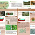
Une biodiversité remarquable, un milieu ouvert sur terrain siliceux, où la végétation naturelle se développe lentement, avec des conditions favorables pour l’installation d’espèces à intérêt patrimonial fort comme le Crapaud sonneur, le hibou Grand-Duc et d’autres rapaces nichant dans les falaises. Ce sont leurs exigences écologiques exceptionnelles qui ont été prises en compte comme référence pour définir le périmètre du site Natura 2000 qui englobe la carrière. Un site pédagogique bien conçu, bien aménagé avec possibilité de cheminement et d’observation en sécurité pour les élèves. C’est à la fois un site communal public et un site du CEN (Conservatoire d’espaces naturels de Bourgogne). Un sentier, libre d’accès et balisé, nous permet un fantastique voyage dans le temps de plus de 300 Ma. L’ampleur du site et du paysage se prêtent à merveille aux explications de tectonique globale et d’interprétation du paysage actuel.
Le site est en accès libre avec une règlementation affichée. Vaste parking auto à l’est immédiat de la carrière. Demi-tour pour cars à l’entrée du chemin empierré, à 300 m du site (possibilité d’avancer sur 150 m et de faire demi-tour par temps sec).
English
Remarkable biodiversity, an open environment on siliceous soil, where natural vegetation develops slowly, with favourable conditions for the installation of species of strong heritage interest such as the Sounder Toad, the Eagle Owl and other raptors nesting in the cliffs. It is their exceptional ecological requirements that have been taken into account as a reference to define the perimeter of the Natura 2000 site that includes the quarry. A well-designed, well-equipped educational site with the possibility of safe walking and observation for the pupils. It is both a public communal site and a CEN site (Conservatoire d'espaces naturels de Bourgogne). A path, free of access and marked out, allows us a fantastic journey in time of more than 300 Ma. The size of the site and the landscape lend themselves wonderfully to explanations of global tectonics and interpretation of the current landscape.
The site is freely accessible with posted regulations. Large car park to the immediate east of the quarry. Turnaround for coaches at the entrance of the gravel road, 300 m from the site (possibility to drive 150 m and turn around in dry weather).
Deutsch
Eine bemerkenswerte Artenvielfalt, ein offenes Milieu auf silikatischem Boden, in dem sich die natürliche Vegetation langsam entwickelt, mit günstigen Bedingungen für die Ansiedlung von Arten mit hohem patrimonialem Interesse wie der Kreuzkröte, dem Uhu und anderen Raubvögeln, die in den Klippen nisten. Es sind ihre außergewöhnlichen ökologischen Anforderungen, die als Referenz für die Festlegung des Umfangs des Natura-2000-Gebiets, das den Steinbruch umfasst, herangezogen wurden. Ein gut konzipierter, gut ausgestatteter pädagogischer Standort mit sicheren Wander- und Beobachtungsmöglichkeiten für die Schüler. Es handelt sich sowohl um einen öffentlichen kommunalen Standort als auch um einen Standort des CEN (Conservatoire d'espaces naturels de Bourgogne). Ein frei zugänglicher und markierter Pfad ermöglicht uns eine fantastische Reise in die Zeit von über 300 Ma. Die Größe des Ortes und der Landschaft eignen sich hervorragend für Erklärungen zur globalen Tektonik und zur Interpretation der heutigen Landschaft.
Die Stätte ist frei zugänglich, wobei die Regeln angezeigt werden. Großer Parkplatz für Autos im unmittelbaren Osten des Steinbruchs. Wendemöglichkeit für Busse am Eingang des Schotterwegs, 300 m vom Gelände entfernt (Möglichkeit, 150 m weiterzufahren und bei trockenem Wetter zu wenden).
Dutch
Opmerkelijke biodiversiteit, een open omgeving op kiezelhoudende grond, waar de natuurlijke vegetatie zich langzaam ontwikkelt, met gunstige omstandigheden voor de vestiging van soorten van groot erfgoedbelang, zoals de Sounder Toad, de Eagle Owl en andere roofvogels die in de kliffen nestelen. Het zijn hun uitzonderlijke ecologische vereisten die in aanmerking zijn genomen als referentie om de omtrek te bepalen van het Natura 2000-gebied dat de groeve omvat. Een goed ontworpen, goed uitgeruste onderwijslocatie met veilige loop- en observatiefaciliteiten voor leerlingen. Het is zowel een openbare gemeentelijke site als een CEN-site (Conservatoire d'espaces naturels de Bourgogne). Een vrij toegankelijk en bewegwijzerd pad neemt ons mee op een fantastische reis terug in de tijd naar meer dan 300 Ma. De omvang van het terrein en het landschap lenen zich uitstekend voor uitleg over de globale tektoniek en interpretatie van het huidige landschap.
Het terrein is open voor het publiek, met gepubliceerde regels. Grote parkeerplaats direct ten oosten van de groeve. Keerpunt voor bussen bij de ingang van de grindweg, 300m van de camping (mogelijkheid om 150m te rijden en terug te keren bij droog weer).
Español
Notable biodiversidad, un entorno abierto sobre suelo silíceo, donde la vegetación natural se desarrolla lentamente, con condiciones favorables para la instalación de especies de alto interés patrimonial como el sapo de la sierra, el búho real y otras rapaces que anidan en los acantilados. Son sus requisitos ecológicos excepcionales los que se han tenido en cuenta como referencia para definir el perímetro del espacio Natura 2000 que incluye la cantera. Un recinto educativo bien diseñado y equipado, con instalaciones seguras para el paseo y la observación de los alumnos. Es a la vez un sitio comunal público y un sitio CEN (Conservatoire d'espaces naturels de Bourgogne). Un sendero de libre acceso y señalizado nos lleva a un fantástico viaje en el tiempo a más de 300 Ma. El tamaño del sitio y el paisaje se prestan perfectamente a las explicaciones de la tectónica global y a la interpretación del paisaje actual.
El sitio está abierto al público con normas publicadas. Gran aparcamiento al este inmediato de la cantera. Vuelta para los autocares en la entrada de la carretera de grava, a 300 m del lugar (posibilidad de avanzar 150 m y dar la vuelta en tiempo seco).
Italiano
Notevole biodiversità, un ambiente aperto su suolo siliceo, dove la vegetazione naturale si sviluppa lentamente, con condizioni favorevoli all'insediamento di specie di elevato interesse patrimoniale come il rospo sonda, il gufo reale e altri rapaci che nidificano nelle scogliere. Sono i loro eccezionali requisiti ecologici che sono stati presi in considerazione come riferimento per definire il perimetro del sito Natura 2000 che comprende la cava. Un sito educativo ben progettato e ben attrezzato, con strutture sicure per il passeggio e l'osservazione degli alunni. È un sito pubblico comunale e un sito CEN (Conservatoire d'espaces naturels de Bourgogne). Un sentiero liberamente accessibile e segnalato ci conduce in un fantastico viaggio a ritroso nel tempo di oltre 300 Ma. Le dimensioni del sito e il paesaggio si prestano perfettamente a spiegazioni sulla tettonica globale e all'interpretazione del paesaggio attuale.
Il sito è aperto al pubblico con un regolamento affisso. Ampio parcheggio a est della cava. Svolta per i pullman all'imbocco della strada sterrata, a 300 m dal sito (possibilità di avanzare di 150 m e tornare indietro in caso di tempo asciutto).