Crêt Monniot
Description
English
Deutsch
Dutch
Español
Italiano
Description
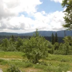
Point culminant du canton de Montbenoît.
Vue panoramique et tables d'orientation sur la Vallée de la Loue, les Plateaux du Jura et les Alpes. Sentier d'interprétation sur la thématique de l'eau (5 km) au départ de l'ancienne Auberge du Crêt Monniot.
Accès en voiture par La Chaux, Gilley ou Arc-Sous-Cicon.
English
Highest point of the canton of Montbenoît.
Panoramic view and orientation tables on the Loue Valley, the Jura Plateaux and the Alps. Interpretation trail on the theme of water (5 km) starting from the former Auberge du Crêt Monniot.
Access by car via La Chaux, Gilley or Arc-Sous-Cicon.
Deutsch
Höchster Punkt des Kantons Montbenoît.
Panoramablick und Orientierungstafeln über das Loue-Tal, die Jura-Hochebenen und die Alpen. Interpretationspfad zum Thema Wasser (5 km), der bei der ehemaligen Auberge du Crêt Monniot beginnt.
Anfahrt mit dem Auto über La Chaux, Gilley oder Arc-Sous-Cicon.
Dutch
Hoogste punt van het kanton Montbenoît.
Panoramisch uitzicht en oriëntatietafels over de vallei van de Loue, de Juraplateaus en de Alpen. Interpretatiepad over het thema water (5 km) vanaf de voormalige Auberge du Crêt Monniot.
Toegang met de auto via La Chaux, Gilley of Arc-Sous-Cicon.
Español
Punto más alto del cantón de Montbenoît.
Vista panorámica y mesas de orientación sobre el valle del Loue, las mesetas del Jura y los Alpes. Sendero de interpretación sobre el tema del agua (5 km) a partir del antiguo Auberge du Crêt Monniot.
Acceso en coche por La Chaux, Gilley o Arc-Sous-Cicon.
Italiano
Punto più alto del cantone di Montbenoît.
Vista panoramica e tabelle di orientamento sulla Valle della Loue, gli altopiani del Giura e le Alpi. Percorso di interpretazione sul tema dell'acqua (5 km) a partire dall'ex Auberge du Crêt Monniot.
Accesso in auto via La Chaux, Gilley o Arc-Sous-Cicon.