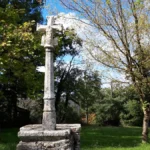
Randonnée – Croix de Bleyssol – Col de Luganhou (Vabre-Tizac) – Le Bas Ségala
My Tourisme > Circuits > Randonnée – Croix de Bleyssol – Col de Luganhou (Vabre-Tizac) – Le Bas Ségala
Description
English
Deutsch
Dutch
Español
Italiano
Description
Durée : 2h – Distance : 7.5 km – Dénivelé cumulé : 200 m
Départ : Vabre-Tizac, parking de la salle des fêtes
Balisage : suivre circuit bleu Les topoguides sont en vente à l'office de tourisme avec les étapes, des informations sur les lieux de visites ainsi que quelques anecdotes historiques.
Retrouvez tous nos circuits sur votre smartphone avec l'application Cirkwi, ou avec un lecteur GPX (ex. GPX viewer) : https://www.cirkwi.com/fr/circuit/1101184-croix-de-bleyssol-col-de-luganhou
English
Duration: 2h – Distance: 7.5 km – Total ascent: 200 m
Start : Vabre-Tizac, salle des fêtes parking lot
Signposts: follow blue circuit Topoguides are on sale at the tourist office, with stages, information on places to visit and a few historical anecdotes.
Find all our tours on your smartphone with the Cirkwi application, or with a GPX reader (e.g. GPX viewer): https://www.cirkwi.com/fr/circuit/1101184-croix-de-bleyssol-col-de-luganhou
Deutsch
Dauer: 2 Std. – Entfernung: 7.5 km – Kumulierter Höhenunterschied: 200 m
Start: Vabre-Tizac, Parkplatz des Festsaals
Markierung: dem blauen Rundweg folgen Topoguides sind im Tourismusbüro erhältlich und enthalten die Etappen, Informationen zu den Sehenswürdigkeiten sowie einige historische Anekdoten.
Finden Sie alle unsere Touren auf Ihrem Smartphone mit der Cirkwi-App oder mit einem GPX-Leser (z. B. GPX viewer): https://www.cirkwi.com/fr/circuit/1101184-croix-de-bleyssol-col-de-luganhou
Dutch
Duur: 2 uur – Afstand: 7,5 km – Totale hoogtewinst: 200 m
Start : Vabre-Tizac, parking Salle des Fêtes
Wegwijzers: volg het blauwe circuit Bij het toeristenbureau zijn topogidsen te koop met de etappes, informatie over bezienswaardigheden en enkele historische anekdotes.
Je kunt al onze routes vinden op je smartphone met de applicatie Cirkwi, of met een GPX-lezer (bijv. GPX viewer): https://www.cirkwi.com/fr/circuit/1101184-croix-de-bleyssol-col-de-luganhou
Español
Duración: 2 horas – Distancia: 7,5 km – Desnivel total: 200 m
Salida : Vabre-Tizac, parking salle des fêtes
Señalización: seguir el circuito azul En la Oficina de Turismo están a la venta topoguías con las etapas, información sobre los lugares a visitar y algunas anécdotas históricas.
Puede encontrar todas nuestras rutas en su smartphone utilizando la aplicación Cirkwi, o con un lector GPX (por ejemplo, GPX viewer): https://www.cirkwi.com/fr/circuit/1101184-croix-de-bleyssol-col-de-luganhou
Italiano
Durata: 2 ore – Distanza: 7,5 km – Dislivello totale: 200 m
Partenza : Vabre-Tizac, parcheggio della Salle des fêtes
Segnaletica: seguire il circuito blu Presso l'ufficio del turismo sono in vendita le topoguide con le tappe, le informazioni sui luoghi da visitare e alcuni aneddoti storici.
Potete trovare tutti i nostri percorsi sul vostro smartphone utilizzando l'applicazione Cirkwi, oppure con un lettore GPX (ad esempio GPX viewer): https://www.cirkwi.com/fr/circuit/1101184-croix-de-bleyssol-col-de-luganhou
Type:
Distance:
départ de la salle des fêtes de Vabre-Tizac, 12200 Le Bas Ségala
Crédits: OFFICE DE TOURISME AVEYRON SEGALA