Rocher du Calice – Saint-Louis
Description
English
Deutsch
Dutch
Español
Italiano
Description
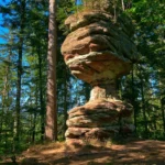
Le Rocher du Calice se trouve en forêt non loin du Plan Incliné, dans la commune de Saint-Louis. La forme de ce rocher est particulière et montre bien comment toutes ces roches sur notre territoire ont été façonnées par l’érosion, pour laisser libre court à notre imagination et y voir toutes sortes de formes, animaux, visages, gravures, ….
Comment y accéder ? Depuis le parking de la Luge du Plan Incliné où vous trouverez le panneau de départ du Circuit des Éclusiers, suivre le balisage point jaune sur 1,2 km en direction du Rocher du Calice. L’approche vers le rocher se fait via un chemin puis un sentier abrupt. Vous pourrez ensuite continuer votre randonnée qui passe par plusieurs passages insolites en sous-terrain puis via la Vallée des Éclusiers, Hofmuhl avant de revenir au point de départ (11,4 km). Carte « Randonnée au Pays de Phalsbourg » disponible gratuitement dans les bureaux d’information touristique. Carte IGN de référence : 3715 OT
English
The Rocher du Calice is located in the forest not far from the Plan Incliné, in the commune of Saint-Louis. The shape of this rock is particular and shows how all these rocks on our territory have been shaped by erosion, to let our imagination run free and see all sorts of shapes, animals, faces, engravings, ?
How to get there? From the parking lot of the Plan Incliné sled, where you will find the starting sign of the Circuit des Éclusiers, follow the yellow markers for 1.2 km in the direction of the Rocher du Calice. The approach to the rock is via a path and then a steep trail. You can then continue your hike through several unusual underground passages and then via the Vallée des Éclusiers, Hofmuhl before returning to the starting point (11.4 km). Map " Randonnée au Pays de Phalsbourg " available free of charge in the tourist information offices. IGN map reference : 3715 OT
Deutsch
Der Rocher du Calice befindet sich im Wald unweit des Plan Incliné in der Gemeinde Saint-Louis. Die Form dieses Felsens ist besonders und zeigt gut, wie all diese Felsen in unserem Gebiet durch Erosion geformt wurden, um unserer Fantasie freien Lauf zu lassen und alle möglichen Formen, Tiere, Gesichter, Gravuren, ? zu sehen.
Wie gelangt man dorthin? Vom Parkplatz der Rodelbahn Plan Incliné, wo Sie das Startschild des Circuit des Éclusiers finden, folgen Sie der Markierung gelber Punkt 1,2 km lang in Richtung Rocher du Calice. Die Annäherung an den Felsen erfolgt über einen Weg und dann über einen steilen Pfad. Danach können Sie Ihre Wanderung fortsetzen, die Sie durch mehrere ungewöhnliche Unterführungen und dann durch das Vallée des Éclusiers und Hofmuhl führt, bevor Sie wieder zum Ausgangspunkt zurückkehren (11,4 km). Die Karte "Randonnée au Pays de Phalsbourg" ist kostenlos in den Touristeninformationsbüros erhältlich. IGN-Referenzkarte: 3715 OT
Dutch
De Rocher du Calice ligt in het bos, niet ver van het Plan Incliné, in de gemeente Saint-Louis. De vorm van deze rots is bijzonder en laat zien hoe al deze rotsen op ons grondgebied zijn gevormd door erosie, om onze fantasie de vrije loop te laten en allerlei vormen, dieren, gezichten, gravures, enz. te zien.
Hoe kom je daar? Vanaf de parkeerplaats van de Plan Incliné slee, waar u het startbord voor het Circuit des Éclusiers vindt, volgt u de gele puntmarkeringen gedurende 1,2 km in de richting van de Rocher du Calice. De benadering van de rots is via een pad en vervolgens een steil pad. Vervolgens kunt u uw wandeling voortzetten via enkele ongewone ondergrondse gangen en vervolgens via de Vallée des Éclusiers, Hofmuhl alvorens terug te keren naar het beginpunt (11,4 km). Kaart "Wandelen in het Land van Phalsbourg" gratis verkrijgbaar bij de VVV-kantoren. IGN referentie kaart: 3715 OT
Español
El Rocher du Calice se encuentra en el bosque, no lejos del Plan Incliné, en la comuna de Saint-Louis. La forma de esta roca es particular y muestra cómo todas estas rocas de nuestro territorio han sido modeladas por la erosión, para dejar volar nuestra imaginación y ver todo tipo de formas, animales, caras, grabados, etc.
¿Cómo llegar? Desde el aparcamiento del trineo del Plan Incliné, donde encontrará la señal de salida del Circuit des Éclusiers, siga las balizas de puntos amarillos durante 1,2 km en dirección al Rocher du Calice. La aproximación a la roca se realiza por un sendero y luego por un camino empinado. A continuación, puede continuar su excursión por varios pasadizos subterráneos poco habituales y, después, por el Valle de los Éclusiers, Hofmuhl antes de regresar al punto de partida (11,4 km). Mapa "Senderismo en el Pays de Phalsbourg" disponible gratuitamente en las oficinas de información turística. Mapa de referencia IGN: 3715 OT
Italiano
Il Rocher du Calice si trova nella foresta, non lontano dal Plan Incliné, nel comune di Saint-Louis. La forma di questa roccia è particolare e dimostra come tutte le rocce del nostro territorio siano state modellate dall'erosione, per dare libero sfogo alla nostra immaginazione e vedere ogni sorta di forme, animali, volti, incisioni, ecc.
Come arrivare? Dal parcheggio della slitta Plan Incliné, dove si trova il cartello di partenza del Circuit des Éclusiers, seguite i segnavia gialli per 1,2 km in direzione del Rocher du Calice. L'avvicinamento alla roccia avviene attraverso un sentiero e poi un ripido sentiero. Si può poi continuare l'escursione attraverso alcuni insoliti passaggi sotterranei e poi attraverso la Vallée des Éclusiers, Hofmuhl prima di tornare al punto di partenza (11,4 km). Mappa "Escursioni nel Pays de Phalsbourg" disponibile gratuitamente presso gli uffici di informazione turistica. Mappa di riferimento IGN: 3715 OT
Lat. 48,7103 Long. 7,2133, 57820 Saint-Louis