Description
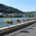
12 km – 2 h – dénivelés 200 m Niveau facile VTT·Situation : Vireux-Wallerand à 45 km au nord de Charleville-Mézières .Départ de la boucle: devant l'office de tourisme – rue du château à Vireux-Wallerand·Balisage : sigle VTT
English
12 km – 2 h – difference in height 200 m Easy mountain bike level-Situation : Vireux-Wallerand 45 km north of Charleville-Mézières Departure of the loop: in front of the tourist office – rue du château in Vireux-Wallerand-Balisage : sigle VTT
Deutsch
12 km – 2 Std. – Höhenunterschied 200 m Schwierigkeitsgrad leicht MTB-Lage: Vireux-Wallerand 45 km nördlich von Charleville-Mézières Start der Rundtour: vor dem Tourismusbüro – rue du château in Vireux-Wallerand-Markierung: VTT-Sigle
Dutch
12 km – 2 u – hoogteverschil 200 m Gemakkelijk niveau mountainbike – Ligging: Vireux-Wallerand, 45 km ten noorden van Charleville-Mézières – Begin van de lus: voor het toeristenbureau – rue du château in Vireux-Wallerand – Markering: mountainbikelogo
Español
¿12 km? 2 h ? de desnivel 200 m Bicicleta de montaña de nivel fácil Localización : Vireux-Wallerand, 45 km al norte de Charleville-Mézières, salida del bucle: frente a la oficina de turismo – rue du château en Vireux-Wallerand, señalizado con el logotipo de la bicicleta de montaña
Italiano
12 km ? 2 h ? dislivello 200 m Livello facile mountain bike Località : Vireux-Wallerand, 45 km a nord di Charleville-Mézières, partenza dell'anello: davanti all'ufficio del turismo – rue du château a Vireux-Wallerand, segnalato con il logo mountain bike